Map of the of states I’ve been to, color coded according to how often:
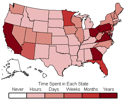
I’ve been to every state in the continental US except Rhode Island and Delaware. The state I’ve spent the least amount of time in are Michigan (just a layover at the Detroit airport) and Idaho (train ride across the panhandle).
Besides these states, the only other places I’ve visited are the Province of Ontario in Canada, and the Mexican State of Sonora. I’ve been all around the United States but don’t get to other countries much.
Most extreme compass point locations for me (not counting time aboard airplanes, though I’d guess that wouldn’t make a difference):
- North: a point near Glacier National Park in Montana
- South: Miami, Florida
- East: Portland, Maine
- West: Portland, Oregon
